Area (Polygon) Tab
![]()
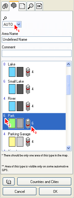
These parameters are applicable only to Area objects. All these settings are uploaded with map into the GPS device.
Control marked with arrow 1 is Individual Zoom Level of selected object(s). If set to AUTO, the global zoom level of respective area type is used (in this case, zoom level of 'Park' type). Zoom Level defines maximum zoom at which the object is displayed in GPS.
Name is text that is displayed on the area in the GPS device.
Comment is text that is displayed when you place cursor on top of the area. Some GPS units display the comment in a same way as the name label
The list at the bottom contains available area types. Always assign the proper type to the area object, because the area type defines how the object is displayed in the GPS. Each row in the list contains type name, color sample and gray scale sample of the area.
Color sample shows the area color and pattern if loaded into GPS with color display. Grey scale sample shows the area color and pattern if loaded into GPS with monochrome display.
Arrow 2 marks Global Zoom Level of areas of 'Park' type. The global zoom level is used for each object of the same type. unless the object has set an individual zoom level. To set global zoom level for any area type, click right mouse button on the area type and use the pop-up menu that appears.
The icon marked with arrow 3 indicates layer in which the object of respective type is displayed. By proper assignment of layers to the types you can achieve one type of area objects to be displayed on top of (or under) the other types.
Objects in layers with higher index are displayed behind areas with lower layer index, regardless of their creation order (the 'Park', for example). To make such area visible, you have to make openings to all areas that cover this area.
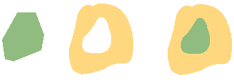
In this example, an opening was made to the yellow area to allow the green area show through.