Routing (Turn-by-Turn Navigation)
Mapwel supports creation of routable maps with turn-by-turn voice navigation. This feature is available only in the registered Advanced version of Mapwel software.
Routable map uses special type of polylines called routable roads. To
create such polyline use the tool with ![]() icon. This tool is intended for manual drawing
of the roads. However, the easiest way of how to make a routable map
is to convert vector map in OpenStreetMap (*.OSM) or cGPSmapper (*.MP) file format to the routable IMG
file, which is compatible with Garmin GPS units.
icon. This tool is intended for manual drawing
of the roads. However, the easiest way of how to make a routable map
is to convert vector map in OpenStreetMap (*.OSM) or cGPSmapper (*.MP) file format to the routable IMG
file, which is compatible with Garmin GPS units.
Such conversion is very easy with Mapwel:
-
Open *.OSM or *.MP file with main menu > File > Open command
-
Upload it to GPS or save it to disc with use of main menu > File > Export Map command.
-
There is also Convert OSM or MP file(s) to routable IMG file command available from the main menu > File. This command allows the batch conversion of multiple files at once and merges all resulting maps into a single GMAPSUPP.IMG file.
Nothing else is needed if you create single routable map. Routable map can be created also from ESRI *.shp files.
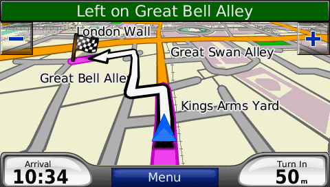
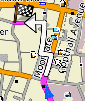
Turn-by-turn navigation with map created by Mapwel from the OpenStreetMap OSM file.
More Options
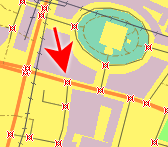
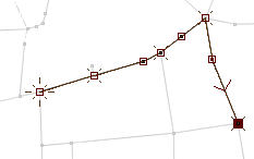
Intersections
Nodes where roads connect each other must be marked as "Intersections" (red crosses on the right-side image). Otherwise, Mapwel will not include them into the net of routable roads. If you import map from *.OSM or *.MP file. the intersections are detected automatically. If you use other files (like *.KML or *.GPX), you have to mark the intersection nodes. There is a "Detect Intersections" command in the main menu > Routing that allows to mark all intersections at once. Also, there is a manual method of marking the intersections - in the editing/creation mode use the pop-up menu to mark the selected node. This pop-up menu also allows to define turn restriction at the node (see Restrictions below)Border Nodes
To allow GPS to navigate between the separate maps when cursor reaches the border of the actual map, the end nodes of map must be marked with "Border Node" attribute. Use the same pop-up menu as in above case to set the Border attribute of nodes.
Restrictions
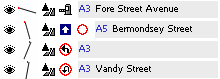
Mapwel allows to define road restrictions (oneway road, toll road, access permission) and node restrictions (left turn, right turn and U turn restriction). These restrictions help the GPS navigation engine to avoid restricted places or directions. Roads with restrictions are displayed in object inspector with icon or multiple icons indicating the type of restriction (picture at the left).
Road restrictions can be set in the Properties window, because they are valid for whole road object. Node restrictions must be set in the creation/editing mode which allows to access each individual node. Use the pop-up menu to set required restrictions at the selected node.
Note: Roads can be drawn with use of straight line and curve elements. Intersection attribute and node restrictions cannot be defined for the middle point of the curve element.
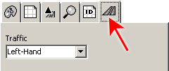
For correct coding of U turns and roundabouts, Mapwel needs to know the driving side of roads in the respective country (map). Please select the left-hand or right-hand traffic for the map you are working on in the main menu > File > Properties window. Default value is right-hand.
Parameters
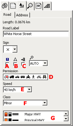
Just like any other vector object in Mapwel, road polylines have adjustable parameters that are accessible in the Properties window. The parameters specific for routing purpose are:
A - "one way" road attribute
B - "show direction" attribute - direction is added to the text label of road when displayed on the GPS
C - "toll road" attribute - tool or fee must be paid to access the road
D - access permission - from left to right: 1. emergency vehicles, 2. delivery vehicles (up to 3.5 tones), 3. cars, 4. public service vehicles (bus, taxi), 5. motorcycles, 6. pedestrians, 7. bicycles, 8. trucks, lorries (over 3.5 tones)
E - max. speed
F - road class. Max. speed and road class define the road hierarchy important for the optimum navigation.
G - type of polyline - defines how the road is rendered on the GPS screen.
Street Names and House Numbering
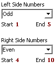
Roads can be assigned with parameters like city, zip code, state and country. GPS uses this information for address searching. It is possible to use different values for the left side and the right side of the road. Also, it is possible to define house numbering along the road to allow GPS navigate to a specific house address.
Use properties window to access the road parameters and select the "Address" tab. Fill-in the Country, State, City and ZIP Code boxes. If you want to define house numbers or separate data for the right-hand side of the road, check the "House Numbering" checkbox. This will enable access to another tab - "Numbering". Enter the rest of address data into this tab.
House numbering allows to use just odd, even or all numbers. Define start and end number and type of numbering for respective side of the road. If there are no houses on respective side of the road, select "None" in the numbers type combo box.
Tips
- OSM files - these files often contain data like building shapes, sport areas, etc. Large number of these objects can slow-down rendering of routable map and make it less legible while driving. If you want to erase such objects from the map, please use main menu> Select > Areas > Type... function to select required type of objects (buildings, for example) and then delete them all at once.
- Routable map can be created also from ESRI shapefiles.
- When roads cross each other at a different height level (bridge or ramp), do not use intersection attribute as the roads are not physically connected on this place. It is recommended to even not put a node on such place to avoid possible automatic detection of intersection by Mapwel software.
- Mapwel software contains tool to analyze the road network and detect errors - main menu > Routing > Road Network Diagnostic Tool
Limits of the current version
|
|
Export from Mapwel into this format |
Import border node attribute |
Import multi-segment house numbering |
Import single-segment house numbering |
|
OSM file |
No | No | No | No |
|
MP file |
Yes | Yes | No | Yes |
|
|
Import of speed limit |
Import of road class |
Import access permission |
Import one-way attribute |
Import turn restrictions |
|
OSM file |
Yes | Yes | Yes | Yes | Yes |
|
MP file |
Yes | Yes | Yes | Yes | Yes |