How to create a roundabout
The roundabout must be created properly to allow GPS recognize it andnavigate driver
with specific instructions.
There is a couple of things that must be taken into account.
Drawing tool
Routable objects (including roundabout) use a special type of polylines called routable roads. To
create such polyline use the tool with ![]() icon. This tool is intended for manual
node-by-node drawing
of the roads.
icon. This tool is intended for manual
node-by-node drawing
of the roads.
Traffic side
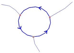
The roundabout is implicitly a one-way road. Its direction depends on the traffic side in respective country. This example is a counter-clockwise roundabout with a right-side traffic. For countries with left-side traffic, draw roundabouts with opposite direction (clockwise).
List of objects
It is important to understand the structure and type of vector elements that form the roundabout and connector roads. In this example, roundabout circle (polyline) is split into 3 pieces (because of 3 connector roads), for easier editing. Therefore, the first 3 items in the Object Inspector list are polylines of Roundabout type (class), with one-way attribute. These features are depicted with small icons. You do not need to use this number of elements, though. A single, closed polyline or other number of polylines can be used as well, as long as intersection nodes are defined properly.
The next 3 items are connector roads. They are routable objects too, but they are of other type (class). Any road type (other than roundabout, of course) can be used here.
Object type (class)
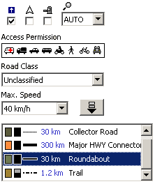
Type (class) is assigned to polyline in the Properties window. This window is accessible via pop-up menu that appears when one or more objects are selected and right mouse button is clicked.
The elements of roundabout circle must be of "Roundabout" type only. The one-way attribute can be turned on, but it is not required as roundabouts are implicitly one-way only.
The connector roads can be of any routable roads type (highway, arterial road, alley, etc.) except the roundabout type.
Intersections
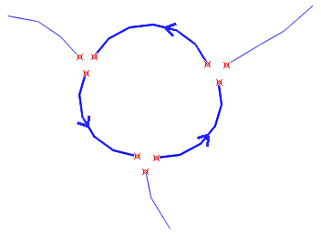
Nodes where roads connect each other must be marked as "Intersections" (red crosses on the right-side image). Otherwise, Mapwel will not include them into the net of routable roads. You can mark the intersection nodes manually in the editing/creation mode, or use an automatic "Detect Intersections" command in the main menu > Routing that allows to mark all intersections at once.
Roundabout at this illustration has all pieces pulled aside to show all required instersections.
Please note that intersection nodes must be defined on all roads in place of connection. It is not sufficient to define intersection node on just one road.
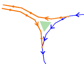
One-way connector roads
Connector roads of higher level may have separate one-way sides. The place of connection to roundabout may contain an island. In such a case, the connector road should look like this illustration. Both sides (each may include multiple driving lanes) are digitized as separate polylines with one-way attribute.
The green triangle just illustrates the island in place of connection. It is not really needed in the map.