Convert
The Convert commands work on objects selected with the Transform Tool (arrow) or in Objects Inspector.
Create Line from Area creates line object from selected polygon object. If polygon object has openings, program will create also lines from openings as a separate objects.
Create Area from Opening creates a new area object from selected opening in an existing area. Opening must be selected in the Parts Inspector window. This command is intended for situation when user needs to create object of other color for a hole (opening) in the area. User should adjust the newly created area or the opening to make them overlay each other, to avoid gaps when displayed in the GPS.
Create Area from Line creates a new area object from selected line object. If area is not closed, program automatically closes it.
It is important to note that above commands will duplicate an object and then convert the new object as selected. Below commands just convert selected objects without duplication.
Area to Opening command can be used to convert areas like land or islands to openings in the underlying area like ocean, for example. Map may display faster in GPS if island is made as an opening in the ocean area, letting the background (yellow) area showing through, as opposite to island being a land area put on top of the solid ocean area. In the first case, GPS has lower number of layers to display. When converting selected areas to openings, some area object must precede selected objects in the list, as newly created openings cannot be a stand alone objects and they must follow after the area object.
Map Feature to POI and POI to Map Feature convert respective type of points into the other type.
Area to POI can be used to convert small areas like buildings into the points of interest.
Area to Transparent Grid Cell serves to create transparent grid from the polygons. This command converts selected polygons to line objects with label in the center of each cell. Label, in fact, is a point without icon. Text is taken from the polygon's "name". For more info please read tutorial on How to Create Parcel Map from ESRI Shapefile.
Swap Object Name and Comment command helps to manipulate objects in the list when using the Sort objects on Name function.
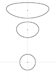
Create Circle around Point creates "circles" of defined radius around all selected points. Near poles very large "circles" look deformed (see below image), because of coordinate system projection. However, real-world distance from center to any point on the "circle" is the same.