Routable Road Tab
![]()
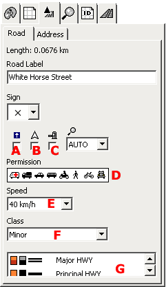
Polylines of this type allow to create routable map with turn-by-turn voice navigation. Besides below mentioned parameters it is possible to define house numbers along the road.
A - "oneway" road attribute
B - "show direction" attribute - direction is added to the text label of road when displayed on the GPS
C - "toll road" attribute - tool or fee must be paid to access the road
D - access permission - from left to right: 1. emergency vehicles, 2. delivery vehicles (up to 3.5 tonnes), 3. cars, 4. public service vehicles (bus, taxi), 5. motorcycles, 6. pedestrians, 7. bicycles, 8. trucks, lorries (over 3.5 tonnes)
E - max. speed
F - road class. Max. speed and road class define the road hierarchy important for the optimum navigation.
G - type of polyline - defines how the road is rendered on the GPS screen.
There are two special road types: Roundabout and Ramp for which GPS generates a special navigation instructions. Mapwel software identifies these road types automatically when importing map from OSM file. It is also possible to convert road to any of these types manually with use of this window.