Line (Polyline) Tab
![]()
These parameters are applicable only to Line objects. All these settings are uploaded with map into the GPS. Please note: objects of this type are not routable, even if they are roads. You have to use Routable Roads objects if you want to use routing (voice navigation) in GPS device.
When accessed through pop-up menu / Properties (i.e. not through editing mode), the total length of all selected line objects is displayed in this tab. You can use it to measure imported tracks, for example. To change distance units use the Edit > Preferences window.
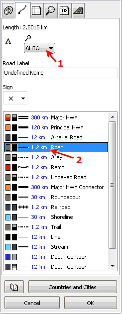
Control marked with arrow 1 is Individual Zoom Level of selected object(s). If set to AUTO, the global zoom level of respective line type (class) is used (in this case, zoom level of 'Road' type). Zoom Level defines maximum zoom in which the object is displayed in GPS device.
![]() Setting of this check box defines whether to display the direction indicator after the line name or not.
Setting of this check box defines whether to display the direction indicator after the line name or not.
Depending on the type, Line object can have:
- Road label and any of the available 6 road signs (roads).
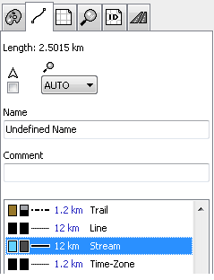
- Normal name label with optional comment.
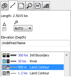
- Altitude or depth label (land and depth contours).
Name is the text that is displayed next to the line or over the line in the GPS. Comment is text that is displayed when you place cursor on top of the line. Some GPS units display comment label in the same way as the name label.
Altitude or Depth label can contain only digits. You can choose the elevation and depth units in the Edit > Preferences window.
Road label can contain both letters and digits.
![]()
The list at the bottom contains available line types. Always assign the proper type to the line object, because the line type defines how the object is displayed in the GPS. Each row in the list contains color icon and gray scale icon, line style and the type name. Icons show the color (or several colors) used for displaying of this line type in the color and monochrome GPS.
Arrow 2 marks Global Zoom Level of lines of 'Road' type. The global zoom level is used for each object of the same type. unless the object has set an individual zoom level.
To set global zoom level for any line type, click right mouse button on the line type and use the pop-up menu that appears.
Next two pictures at the left side illustrate tab with normal Line object and tab with elevation (depth) Line object.