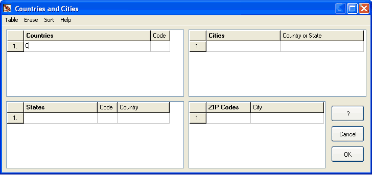
Countries and Cities Table
Access this table either via main menu > File or click Countries and Cities button in the Properties window.
Animated Image
Countries and Cities Table is used for City, POI (point of interest) and routable roads objects. If you want to use City objects in your map, you should fill this table first. City objects with undefined name are not transferred into the GPS.
If you use POI objects in your map, you need to fill this table only if you want to use country, state, city or zip code fields in the POI address. Any field in the POI address can be left empty.
To fill Countries and Cities Table follow these steps:
- Enter countries and their codes (codes are optional) into the first table. To add new a line, press the F2 key on your keyboard. To delete last line in the table, hit F3 key on your keyboard.
- If Country has states, enter states and their codes (codes are optional).
- Assign respective country to each state. Click right mouse button on the 3rd column in the States table to access pop-up menu with countries list.
- Enter cities.
- Assign respective country or state to cities. Click right mouse button on the 2nd column in the Cities table to access pop-up menu with countries and states list. Countries are marked with a blue square and States are marked with a red square.
- Enter ZIP codes.
- Assign respective city to ZIP codes. Click right mouse button on the 2nd column in the ZIP Codes table to access pop-up menu with cities list.
Main menu in this window contains following commands:
Table. Use it to save and open Countries and Cities Table. If several maps use the same table, you can save the table and open it in another map.
Import command allows to load countries, states, cities or zip codes from separate text (*.TXT) files. TXT file must have following format:
- Item1/Code1
- Item2/Code2
- Item3/Code3
- ...
"/Code" section optional and it is valid only for countries and states (for example: Great Britain/GB). TXT files with cities and zip codes should not have "/Code" section.
Edit. Use it to add or delete last line in the table.
Erase. Use it to erase tables in this window.
Sort. Use it to sort tables in this window alphabetically. If the are objects in the map which are already using Countries and Cities table, they are automatically adjusted.
Valid characters
- Country, State, City - letters and - & ' /
- Country and State Code - letters
- Zip Code - letters and digits